
Tornadoes develop during thunderstorms and are the most violent weather phenomena at small scales. The whirling mass of air is called a vortex and consists of water droplets, dust and any debris that has been torn apart from the Earth’s surface. The wind speed of the vortex typically reaches 110 miles per hour (mph). Tornadoes can last anywhere from several seconds to more than an hour, and travel at speeds ranging from 10 to 30 mph.
The most likely areas where tornadoes will occur are in flat areas of North America and Australia. They almost never occur in colder regions like Norway, Denmark and Antarctica. In the United States, around 1200 tornadoes are reported each year. It is possible for Tornadoes to develop during any season and at any time, but most often they will occur in the spring and summer months, and develop in the afternoon between 3 and 9 P.M.
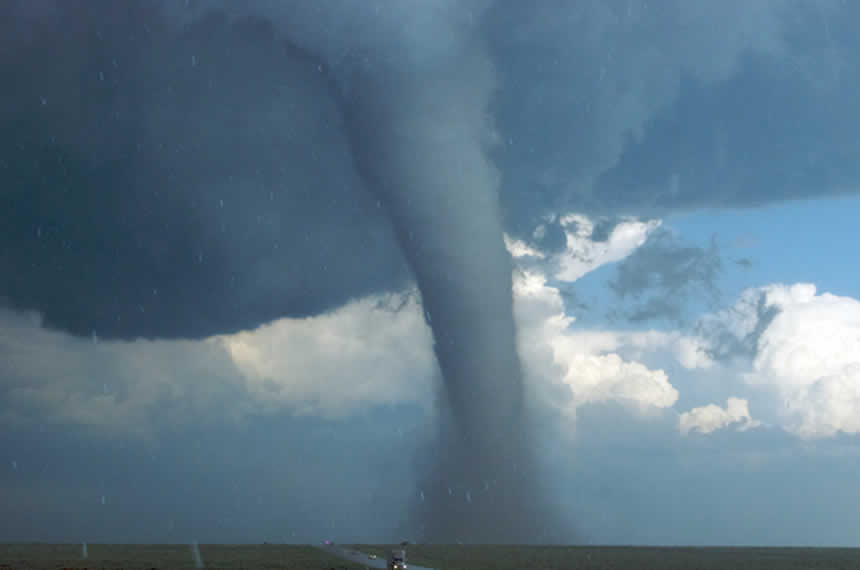
How do Tornadoes form?
Tornadoes spawn from thunderstorms, which need an unstable atmosphere in order to form. The atmosphere is considered unstable if temperature rapidly decreases with increasing altitude. If these conditions are present, deep cumulus and cumulonimbus clouds can form. These clouds develop when warmer air with a high concentration of water vapor (moist) rises to the sky. The water molecules within the ascending current begin to change from gas to liquid or solid phase when the air surrounding them becomes cold. The newly condensed water molecules form the clouds of the thunderstorm.
Not all thunderstorms spawn tornadoes – in fact the majority of them do not. Several conditions are required in a thunderstorm to form a tornado. The first is that the deep cumulus and cumulonimbus clouds develop in an atmosphere where the wind speed greatly increases with altitude. This is sometimes referred to as vertical wind shear, and it will initiate rotation of the rising air. The strong wind shear produces air that rapidly spins horizontally relative to the ground, and the rising air will tilt this spinning air so that it rotates vertically. If this rotating motion persists long enough, the thunderstorm becomes a supercell, which is the next condition required for a tornado to form.
Within the supercell, rain begins falling with descending currents of cold and dense air. Because of the changes in pressure these descending currents cause in the atmosphere, the vertically rotating air intensifies and eventually, reaches the ground. At this point the tornado forms. The tornado begins to disappear as cold flowing wind from the precipitation area begins to choke it.
The Fujita Scale and Enhanced Fujita Scale
In 1971, Dr. Theodore Fujita established the first scale that classified tornadoes, and it was based on the damage caused by this weather phenomenon. Presently, a slightly different scale is commonly used to rate them: the Enhanced Fujita (EF) scale. In the EF scale, different ranges of wind speed estimates are associated with the potential damage that such wind speeds might cause. It includes six levels that go from zero (EF0) to five (EF5). A weak tornado that damages trees but not major structures, with air flowing at speeds between 65 and 85 mph, is an EF0 tornado. If the wind speed reaches values higher than 200 mph, thereby leading to the destruction of buildings and deformation of skyscrapers, it is an EF5 tornado. EF3 (or greater) tornadoes are unlikely, but do occur.
There is an increasing trend of the most common type of tornado (EF0) reported over the last few decades in the United States. This trend does not directly imply that these types of events will occur more often. The massive growth in the human population enlarges the area with observational systems, and might explain this increasing trend. Still, the Earth’s hydrologic cycle (water cycle) could potentially change if global warming occurs, which could possibly alter the frequency and intensity of extreme weather events.
Identifying the formation of a Tornado
In a thunderstorm, ragged bands of low clouds that extend from the biggest storm tower are usually caused because air near the ground is being gathered. Some of these ragged bands may begin to look like spirals. If so, it is because the air within them is rotating.
Another clue that indicates air in a thunderstorm is rotating and may lead to the formation of a tornado is a flat cloud band which extends from the eastern edge to the east or northeast in the base of the thunderstorm which does not contain rain.
A different identifier is an isolated low cloud in the base of the rain-free part of the thunderstorm which persists for 10 to 20 minutes. This is known as a wall cloud. If air is rotating within this lonely cloud it will indicate that there are strong surface winds flowing into the cloud.
A bright area in a thunderstorm near a wall cloud is yet another attribute. This bright area often looks like curtains of rain around the base of the clouds and is called rear flank downdraft. It indicates that air is flowing towards the ground and it descends parallel to funnel of the tornado.
Tornadoes in Literature, Film and Culture
- The most famous twister in literature and culture is in “The Wizard of Oz”, starring Judy Garland as Dorothy. In it, the twister picks up Dorothy’s house and drops it on the Wicked Witch of the East, in the Land of Oz.
- Another popular film was Twister, made in 1996, that starred Helen Hunt and Bill Paxton as storm chasers.